Tuesday, May 27, 2014

Up to Canada

Pushed along again by rain, left Bozeman, MT and began to head towards British Columbia, Canada.  Most of the drive was uneventful but covered some really beautiful areas of the country that I've never seen before.  Crossing into Idaho from Montana is just a dense rolling forest with trees so thick I think you could wander in 5 feet and not know which direction you came in.  

Also saw some pretty funny things on the road.  My favorite was the plane bodies on a flatbed train car.  The drive through Idaho was one long climb followed by another plunge down from the Rockies to Spokane, WA.  After Spokane, the Columbia Plateau covers the middle of Washington and I was treated to one of the best sunsets of the trip.  Pulled off at a rest area and just stood in 
the grass watching the sun go down.
Kept driving into the night were I stopped at rest area along highway 90 adjacent to a large wind farm.  I could see the flashing beacons of light from the turbines for miles before I reached them.  Settled in, read a few pages of my book and slept soundly.  

Woke up the next morning hoping to see some of Seattle and spend a little time in the city.  As soon as I rolled in, immediately overwhelmed by the amount of traffic and people.  I am just not a city guy.  Stopped at REI to pick up a few last minute Alaska items and then got out of the city pretty quickly.  Plan on spending some more time on my way back through after Alaska but I just wanted to get out of the traffic this time around.

Crossing the border was really stressful.  I got a guy with jet black hair slicked back to a sheen and a set jaw.  Wrap around Oakley sunglasses and bullet proof vest completed the outfit.  As soon as I rolled up, the interrogation began.  Every answer to each of his questions only seemed to cause issues. and would result in the playback of my story with errors inserted, as if her were trying to trip me up.  Didn't like my explanation for coming into the country, didn't like my camping gear, and didn't seem to like me either.  Was fully prepared after 10 minutes of on edge question answering to be turned away and told to head back to Washington.  Then, he handed me back my passport, waved me through, and I was good to go.  The whole time, this man's poker face didn't break for a second.    

Cruising over the border, pulled off to check out my map only to discover that about 10 pages from my road atlas were missing, coincidentally the exact 10 pages I wanted to look at.  Thanks Rand McNally.  Just decided to follow signs to Vancouver and figure it out from there.  

Made it to Vancouver right at rush hour which was a disaster.  Horns honking, cars bumper to bumper, and me sitting there already more than a little stressed from my border interrogation.  Not a good combination.  Inched my way through the city and then headed up the Sea to Sky highway towards Whistler and my first real bed and shower in almost two weeks.

Never get tired of the drive along the fjords and dense forests up to Whistler.  Still one of my favorite drives. Arrived at Whistler Creekside, promptly got out of my car, headed to the shower and stood under the water for a while before sleeping like a rock for about 10 hours.  Welcome to Canada.

Bozeman Montana

Arrived in Bozeman after some packed days of Yellowstone.  The geysers, hot springs, and geology were incredible but the adjustment to big crowds was a little strange.  I no longer had things to myself, but had to share with tour buses full of people. 

From freecompsites.net, found a great little place called Battleground.  It's located in Helena National Forest and is a great free sight only about 20 minutes out of town.  I've got photos below of what 20 minutes outside of Bozeman is like.  Pretty incredible.


Good night sleep and no bear sightings yet except for a few in Yellowstone.  Regardless, took my first full day in town to head to a local outdoor gear store and pick up a can of bear spray and a little bear bell just in case for my hikes.  Not sure if the spray will do to much if a bear really wanted to make me lunch but at least I know have some more confidence when I do head out. 


One of the reasons I wanted to make Bozeman a stop is to check out Montana State's campus as it's on the short list for graduate schools.  Bikes around campus, wandered into a few buildings, and spent some time in the library.  Every direction you look on campus, you are surrounded by snow covered peaks and rolling hills.  Not a bad place to study.  Biking back to my car, stopped by Bridger Brewing.  Great bear and met a guy named Shane, who had just moved into town.  He gave me the rundown of Bozeman and sold me pretty hard on the place.

Pulling into my campsite, saw a forest ranger truck stuck in snow up to its doars.  Alan (unfortunate soul in the truck) said he had "made it" but let off the gas before he was through and was now shoveling away.  I lent a hand and pretty quickly we had the truck out.  Quick tip, if you jam pine boughs under tires when they are spinning in a snowbank, gives plenty of traction to pop you right out.  In return for my help, he gave me a nice pair of work gloves that I'm sure will come in handy up  in Alaska.

Cooked some dinner, read a book for a while, and then watched the sun setting over the mountains.  The first ray of sun that I really had seen since arriving.  Seems that rain follows me everywhere.


My last day in Bozeman, I spent the morning doing some slacklining and then planned on hiking Sypes Canyon Trail.  Got rained out with a heavy storm coming over the mountains that didn't seem as if it would stop anytime soon.  Took the time to run a few more errands in town and then started to head towards Spokane, WA.  

Monday, May 26, 2014

Yellowstone National Park


Waking up at the rest stop near Sheridan, I began the day driving on Wyoming's great plains, before steadily climbing into the abutting Big Horn Mountain Range that rises from the plains.  To everyone back in Houghton who was complaining about snow... yep, still above car height in the mountains and parts of Yellowstone were no better.

After the mountain climb came the plunge to the intermountain Bighorn River Basin.  Hardly had to press the gas pedal at all for probably an hour.  Finally felt like I had moved west.  All the mountains followed by desert plains was pretty cool.

Got a nice welcome to Cody, WY.  They are proud of two things there, their beef and apparently their women ranchers too.  If I was a different person, may have been more interested in both but decided a cattle woman was too much woman for me.  

Moving through Cody, made a stop at Buffalo Bill Dam to the west of town.  One of the first concrete arch type dams built and at 325 feet tall, the highest when it was first completed.  Head to nps.gov for more information on the dam.  In stopping at the visitor center, stumbled upon the credentials of the  Construction Engineer for the project.  Did things a little different back then.


Buffalo Bill Resivoir, which receives water from the
Shoshone River.

With all my stops, made it to the park later in the day and decided to camp just outside the park.  As I was walking back to the self pay kiosk, the camp volunteer asked me if I would be sleeping in my car and I said no.  His response was, "I would prefer it if ya did.  Because of the bears.  Don't want ta find ya, you know..."  I asked if he had seen any bears recently and responded with a no.  Decided to sleep in the car anyway and avoid any trouble and let me head out early in the morning to Yellowstone. 

So, now to the onslaught of photos.  The first batch are from the park's east entrance, views of Yellowstone Lake, and the drive from West Thumb to Old Faithful.  That is a small fraction but entails about 65 miles of roadway.

Looking across the tip of Yellowstone Lake towards active hot springs.
Lone bison munching away on 
grass along the shores of 
Yellowstone Lake.
Low clouds and bank of fog hovering over the shores of Yellowstone Lake.

During the drive, got to check something off my to do list.  Crossed the continental divide by car.  Have done it by plane plenty of times but first time via ground transportation.  So much snow still on Yellowstone's east side.  

 After driving for a while, finaly made it to Old Faithful and the Upper Geyser Basin.  The next group of photos is just a few from my day spent here.  I recomend having a bike with you while you travel around Yellowstone, especially at the Upper Geyser Basin.  Things can be spread out and having the bike allowed me to see multiple geyser eruptions, which I would not have been able to see otherwise.  


All geyser eruption times are listed on a board in the Old Faithful Visitors Center.  That was my first stop to plan my visit.  Watched Old Faithful but my favorite geyser eruption was Grand Geyser, erupting for nearly 15 minutes with water shooting up to 200 ft!

One of the many little pools in the 
Upper Geyser Basin.  
Grand Geyser eruption behind me.
Another deep Upper Geyser Basin Pool.
Grotto Geyser, one of the more interstingly shaped geysers.
Most of it has eroded away.
After a pretty full day at Upper Geyser Basin, continued on to Madison and stopped at Midway Geyser Basin.  Midway Geyser basin was a hotspot for tourist busses shuttling people around.  My favorite being tourist group, named Sea Gull Holiday had neon yellow buses that were hard to miss.

Panorama of Midway Geyser Basin
One of the larger pools at Midway Geyser Basin.  Wind blowing in the
wrong direction to see the pools clearing which is a shame.
The only pool really visible at Midway Geyser Basin. 
Boardwalks guiding you around the basin.  Lots of small children
running around, wich made me a little nervous.
The overlook at Midway Geyser Basin was
one of my favorite views at Yellowstone

Reached Madison campground later in the evening.  Had to wait in line for a while to register as it is one of two campgrounds open in the park at mid May.  Set up camp and went for a walk along Madison River.  Storm clouds began to billow over the mountains so headed back to camp.  The site next to me was occupied by a nice couple who were trekking from Arizona to Montana for internships.  They had done a lot of world travel but not much in the U.S. and we talked for a while before combining our food resources for dinner.  We became pretty absorbed in conversation and didn't notice an elk about 20 feet from our picnic table.  A couple walking their dog stopped and focused their attention in our direction, which prompted us to say hi and ask if they would like to join us.  The couple just pointed behind and said no thank you.

Got up early and had coffee with my neighbors before heading out to Norris Geyser Basin. On the way, stopped at Gibbon Falls, situated about 10 minutes north of the Madison junction.  Don't be fooled by the photo, the falls tumble about 80 feet to the river below.

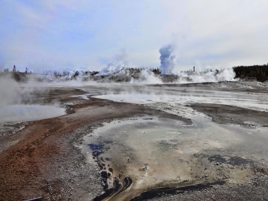
Norris Basin is really apocalyptic looking, with an overcast skye accentuating the feeling. Got there early and missed the heavy crowds. True to form, Sea Gull Holiday pulled in and clogged the parking lot with tourists right as I was trying to leave. 

View of basin from southern corner.

The colors in and around geysers are from microbial mats.  These
microbes are named extremophiles for their ability to survive in
very extreme conditions.  These microbes contain chlorophyll, resulting
in their green color.

Here is the reason I liked Norris Geyser Basin the most.  You emerge from
the visitor kiosk with a perfect view of the basin from above.
I continued on to Mammoth Hot Springs.  This area was already packed with people but did manage to snap a few photos and find a couple of terrace trails no one else seemed to be interested in.


Following Mammoth, had my fill of the crowds and was ready to head out towards Bozeman Montana.  Made it about as far as Livingstone before a big storm that had been building hit.  Parked under a gas station awning to ride out the storm and headed into McDonalds for some coffee and wifi.  Hear a lot of people talking about hail damage so seems that I was lucky to miss the worst parts of the storm.  After an hour or two, the storm cleared and finished the trip to Bozeman.

Friday, May 23, 2014

Home Sweet Hoome

As good a time as any to give a little tour around my home for the past week and change.  I have set the tent up a few times but have mostly been sleeping in the back of the Subaru as low thirties are typical night temps.


The majority of my things fit on the left side of the car, with only my shoes and toolbox in the front.  Directly behind the drivers set, three drawers house my cooking supplies, clothing, small gear items, and my toiletries.  Hiking backpack comes next holding my spare clothing and dirty laundry.   Have mostly been wearing the same pants and rotating between two shirts.  Really need to wash those.....   

The right side of the car is where I sleep.  Two old foam peices, salvaged from the reusit store, have been my bed which is suprisingly comfortable.   I use a lightweight, 20 degree down quilt from Hammock Gear (black), supplemented with a lightweight synthetic quilt and fleece liner (both red) made by yours truly for colder nights.  A really good sleep system that doesn't take up too much space at all in a pack. 

Food takes up two egg crates in the back (not shown, in bear proof storage) followed by my sleeping clothing and large jug for water.   The six gallon jug has really come in handy when I stay at rustic sites as I don't need to come back to town to refill water often. 

Photo to the left is usually how my camp looks when I don't have the tent set up.  You can see the bear proof storage locker in the photo too.  These are really common at camping areas the further west you go.  

As for food, have been a big fan of the little rice pouches you can find at any grocery store.  Just boil water, pour in the bag, and place the bag in an insulated envelope to cook.  The insulated envelope allows the rice to keep cooking without wasting fuel for the stove.  Plus, eating right out of the bag cuts down on dishes.  Only thing is, make sure you have a long handled spoon when eating from the food pouches to keep your fingers from gettin rice all over them.

For breakfast, typically make oatmeal with raisins, almonds, a little coconut, and honey.  Have a cup of coffee with it and its a good way to start your day. 


Thursday, May 22, 2014

Black Hills National Forest and Heading to Yellowstone

Feeling significantly more patriotic, I headed away from Mt. Rushmore, taking the Peter Norbeck Senic Byway with geologic formations jutting out of the trees and towering over the roadway.  Driving the loop, I headed to the west end of Black Hills where road construction really slowed me down.  There was literally no road.  You follow a pilot car that guides you around bulldozers and workers, both of whom are not paying any attention to the car caravan.  

I took a pretty sketchy dirt road into the park's interior, reaching Deerfield Lake.  At the lakeside picnic area, fired up the stove to make coffee with a nice dinner of hummus, red peppers, and string cheese.  A truck stopped by while I was eating and this guy named Cory stepped out with his beagle puppy.  Not sure if you've ever seen a beagle puppy, but it'll make your heart melt.  He wrote for a local magazine and gave me hikes I needed to do and areas in which to camp.  I told him I was headed for the west coast and Seattle, with his response being, "f**k Seattle.  I've lived there and this place is supreme!"  

Black Hills makes free camping really easy by allowing you to pull off designated dirt roads and set up camp within 30 feet of the road.  Any ranger station will give you detailed maps highlighting camping areas.  One of my favorite sites so far this trip and it being free doesn't hurt either.  Had a perfect view overlooking Deerfield lake, the sun setting behind the hills, and didn't see another person anywhere near my camp area.

Woke up, made some oatmeal and coffee and headed to Harney Peak trail.  The trail winds through rock outcroppings of limestone before coming to a clearing, then climbing again to an old fire watch tower.  I took the long way on this hike, combining three different trails together to make a 12 mile loop with pretty significant elevation gain, reaching about 7500 ft.
Didn't see anyone else on the trail until the fire tower, where a 5th grade class was having a field trip.  Why couldn't I have gone to that school?  Panoramic views in every direction.
The hike down was pretty slow going.  A storm had blown through recently and downed trees littered the trail.  After about 6 hours of hiking, made it back to the car.  
For some reason, got a really bad craving for a Burger King "veggie" burger.  Nice not to cook and clean dishes for a change but my stomach paid the price.  Travel tip about Burger King.  Yes, they do have free wifi but the catch is they don't put any outlets in their eating area.  Probably to keep moochers, such as myself, from milling around for too long.

Rain Thursday (5/15) evening pushed me towards Yellowstone. Wyoming lived up to the hype of having no one in existence within the state.  I've never driven so long on an interstate without seeing another car.  Nobody in front or behind me on my side and going the opposite direction was ghostly empty too.  Pitch black.  Nothing.  

Rain picked up and laxed off for most of the drive making my progress pretty slow.  Learned something new about interstates, at least this is true for Wyoming.  When a rest stop is listed on the map, it doesn't necessarily mean a rest stop that most of us are used to.  They are simply small little pull offs on the highway,  similar to a pull through driveway.  Not a good place to sleep for the night as a semi would easily crush the Subaru.  Getting pretty tired, rest stop signs would appear only to signal another pull through, leading to dashed hopes and frustration.  After numerous false alarms, I found an actual rest stop near centra Wyoming and the town of Sheridan.  Brushed my  and then fell into a sleep coma.  That is one thing that has been no problem on this trip, coma sleep.


Sunday, May 18, 2014

Badlands and Mt. Rushmore


After spending the weekend in Houghton, MI and a few days in Minneapolis, MN, I left early Tuesday (5/13),  heading to Badlands National Park on the west side of South Dakota.  Corn fields, cows, and flatness were all I saw for hours.  On highway 90, some cows decided to break outta jail.  I crawled along at 5 mph as the one brave cow jogged alongside, pooping the whole time, before deciding to stand directly in front of my car and ponder life for a while.  The other cows just looked on, not knowing what to do with their new freedom.      

Badlands National Park couldn't have come soon enough.  I expected boring in South Dakota and it delivered for some pretty long stretches.  Got my National Park pass which for $80.00 gets you unlimited access to all national parks for one year.  Good work government.  

Badlands  Wall (left) is a 60 mile long formation that defines the park's borders.  Nearby, bighorn sheep nibbled on some grass.  Gaining access to the parks interior involves following a winding road through even more geological formations before funneling down to the prairie below.  
I decided to camp on the west side of the park at Sage Creek. 
Bison greeted me at the campsite and they couldn't care less that I or anyone else was there.  On a side note, what is the difference between bison and buffalo and what is the correct term here?  According to my rigorous Wikipedia research, the American bison resides only in North America (obviously), while the two main types of buffalo actually reside in Africa and Asia.  The European bison does live in isolated parts of Poland.  Basically, if it's in North America, probably not a buffalo.  Feel free to use this information to condescendingly correct your friends and impress them with your new Wikipedia knowledge.  

I parked my car, set up the tent, and took a long walk to take in the view, bison herds, and sunset.  Below is a photo of the Sage Creek Basin with a few bison hangin around.  Kinda hard to see the bison but they're there.


Early the following morning (5/14), I headed to Mt. Rushmore and Black Hills National Forest.  Arriving at Mt. Rushmore, kinda hard not to feel a little American pride.  
What other place will blast the side of a mountain off just to commemorate the "founding, expansion, unification, and preservation" of their country?    Washington, Jefferson, Lincoln, and Theodore Roosevelt represent each item listed in my semi-sarcastic, but  awe inspired quip.


On the left, had a nice couple take a photo of me in front of Mt. Rushmore while right is the actual model used for pointing, a process of ensuring the actual moonument had proper scale.  Mt. Rushmore stands 60 ft. tall (size of the faces) while the model is a 1/12 the size.

Black Hills National Forest was my next stop and I'll have an update on this shortly.  Also coming sooon will be a post highlighting a pretty serious environmental problem of the Black Hills,  the mountain pine beetle.  

Check Facebook for more photos of my trip.